
Finding Bethany Street Addresses
Ownership and residence are different questions in Bethany. The strongest current chain begins with an address in the Oklahoma County Assessor Public Access System, then moves from the account and legal description to the GIS map and County Clerk index. A tax card may identify an owner and the address where a tax bill is sent. It does not prove that person lives at the property. The address, parcel account, lot and block, and deed reference are the useful pieces to carry forward.
- Enter the street number, direction, and street name in the assessor search. If an exact entry fails, use the documented
%wildcard for a partial street or block and check the returned situs addresses one at a time. - Copy the account number, legal description, owner, mailing address, and deed or sale references from the parcel card. Compare the physical situs with the mailing address rather than treating them as interchangeable.
- Open the parcel in the Oklahoma County GIS viewer. Parcel and city-boundary layers help place the address and identify the legal parcels around it.
- Search OKCC.ONLINE with the legal description, lot and block, address wildcard, or current owner as grantee. Review document type before treating an instrument as a transfer.
- For an older household, compare a reverse street entry in library or OHS materials with the deed date and published newspaper evidence. Use the voter portal only to verify an already-known person, not to create a street roster.
That sequence keeps the Bethany street directory tied to records that have an address key. It also separates a present parcel fact from a past household clue.
Bethany Assessor Street Search
The assessor form is the practical starting point for a current Bethany address. It accepts owner, physical address, account number, subdivision, block, lot, map number, deed book and page, and occupant or building name. Owner names are entered last name first, and a percent sign can widen a partial name or address search. An address can be absent when land lacks a situs address or when the record is keyed chiefly by legal description, so the subdivision and lot fields are important fallbacks.
The public assessor form shows the following captured search choices. Fields and controls can change, but the record structure explains why a street query may need more than one pass.
| Search field | Useful entry | Street research use |
|---|---|---|
| Physical Address | Number, direction, street; % for a partial string | Locates assessor-indexed situs addresses |
| Name | Last name first; partial values accepted | Tests a recorded owner after an address search |
| Real Account | R plus nine digits | Returns to one parcel after a broad result |
| Subdivision, Block, Lot | Plat and legal-description values | Bridges an old addition to a modern street |
| Deed Book and Page | Reference from an abstract or deed | Connects the parcel card with title research |
The captured assessor search illustrates the address, owner, account, subdivision, map, deed, and building-name options available for Bethany parcel work.
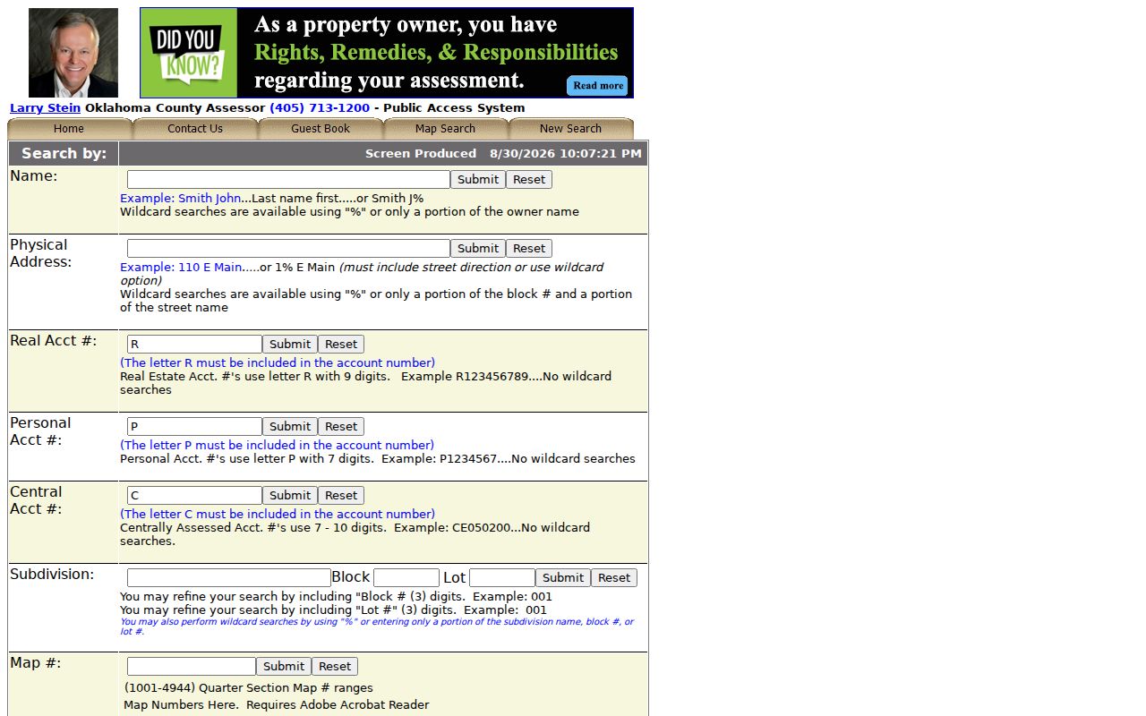
Use the resulting parcel card as a research checkpoint, then verify its owner and legal description against the map and deed index before drawing a conclusion about a Bethany address.
Note: A wildcard can broaden a search quickly, so review every returned situs address instead of assuming one result represents an entire street.
Bethany Parcel Cards by Address
A parcel card gathers several identifiers that otherwise appear in separate systems. Record the owner, situs and mailing addresses, account number, legal description, values, tax year, exemptions, building description or sketch, sale history, and GIS link. The mailing address can be a useful lead, especially when it differs from the Bethany situs. It can also belong to a trust, estate, lender, tax service, or relative. Treat it as tax-correspondence data, not proof of a current household.
- Parcel
- A taxable tract or lot in the assessor system, usually tied to an account number and map geometry.
- Situs address
- The physical location used for assessment, city permits, GIS, and street navigation.
- Plat
- A recorded map that lays out an addition, lots, blocks, streets, or easements.
- Criss-cross directory
- A reverse directory arranged by street and address rather than solely by a person’s name.
Homestead status can support an owner-occupancy inference, but it is not conclusive. Exemptions can lag, be absent, or reflect a filing condition. Tax payment questions belong with the Oklahoma County Treasurer, whose public system covers the current year, six prior years, and unpaid years or tax-sale liens.
Bethany GIS Street Browsing
The county GIS viewer makes a Bethany block visible as parcels instead of a list of names. Search by owner, physical address, account, or a centerline and intersection. Turn on parcel and city-boundary layers, then inspect each neighboring polygon and follow its assessor link. District, school, floodplain, contour, hydrology, and aerial layers provide context, while the account and legal description provide the durable record keys.
For orientation, ODOT’s Bethany city map shows the city limits and Route 66/39th Street. City code also describes wards with numbered NW streets and north-south streets including Rockwell, Mueller, Wilburn, Council, and Glade. A ward or map layer is geography, not proof that a person owns or lives on a parcel. The current ArcGIS controls may change, and the map is not a legal survey.
Note: GIS controls and layer dates can change, so preserve the parcel account and legal description before relying on a map display.
Bethany Deeds Along Streets
Recorded title work belongs with the Oklahoma County Clerk, Registrar of Deeds. The office holds deeds, mortgages, releases, liens, plats, and related land instruments from the territorial-era record environment through current filings. In OKCC.ONLINE, an address search can use a street string or wildcard, while platted land can be narrowed with lot, block, and subdivision. For unplatted land, section, township, range, and quarter descriptions are available.
Result metadata includes instrument number, document type, recording date, book, page, grantor, grantee, legal description, and reference number. Search a buyer as grantee or either party, read the purchase deed, then search the seller as grantee in an earlier period using the same legal description. A mortgage release, easement, lien, or quitclaim can name people without transferring title. Free online images are unofficial and redacted; use the Clerk for official unredacted or certified copies and for material that the digital index does not expose.
The county records a dynamic indexed-through date, so an online miss does not prove an instrument was never recorded. Older books, plats, microfilm, or a Clerk inquiry are the next route when the index ends.
Note: The visible indexed-through date changes dynamically, so a missing online result may need a Clerk request or physical-record follow-up.
Bethany Street Directory Records
Each address source carries a different kind of evidence. The Bethany street directory approach works best when the user compares those source limits rather than collapsing them into one claim about a household. The table shows the address-keyed sources that can be checked, including their access limits.
| Address record | Custodian | Useful evidence | Access route |
|---|---|---|---|
| Parcel card | County Assessor | Owner, situs, mailing address, account, values | Free public search |
| GIS parcel | County Assessor | Parcel geometry, adjacent lots, city and district layers | Public map viewer |
| Deed or plat | County Clerk | Grantor, grantee, legal description, title sequence | OKCC.ONLINE, Clerk copy route |
| Tax account | County Treasurer | Paid or unpaid years and tax-sale liens | Public account, name, or address search |
| Permit or code file | Bethany Community Development | Applicant, contractor, project, inspection status | Citizenserve account or file request |
| Historic street entry | MLS or OHS | Published occupants, address, and directory notation | Library, Research Center, or licensed collection |
A recorded owner can be confirmed in title records. A historical directory entry can place a person at an address at publication time. Neither source by itself identifies every member of a present household.
Bethany Permit Address Files
Bethany Community Development uses Citizenserve for permits, planning applications, inspections, code complaints, business licenses, home occupations, special events, and mobile-food permits. The system is organized around accounts and applications. Research did not identify a public, address-wide result browser. For a city file, identify the address, date range, and record type in the request rather than assuming a portal search will show all past activity.
A permit may name an applicant or contractor and describe a project, inspection, or status. That is construction evidence, not occupancy proof. The same caution applies to code files, which can need redaction before release. The City Clerk and Finance documents page publishes an Open Records Act request form and municipal records materials when a public file is needed beyond the online workflow.
Bethany Voter Street Limits
The Oklahoma Voter Portal requires last name, first name, and date of birth. It can verify registration and district or polling information for a known person, but it does not offer a public Bethany street browse. A name match should be checked against a parcel, directory, or another appropriate record because people with the same name are common and registration does not prove occupancy on every date.
Qualified requesters may seek a full voter file through the state’s EDW process under 26 O.S. §7-103.2, with an authorization category, attestation, and rules against unlawful commercial marketing and certain sharing. Protected voters and Address Confidentiality Program participants have safeguards that remove or substitute address information. A by-street request must follow those limits rather than becoming an unrestricted neighborhood list.
Note: The public voter form is a person-verification tool, so a street query should stop at lawful individual confirmation and protected-record rules.
Bethany Grid and Wards
Bethany’s compact street system is shaped by numbered NW streets, named cross streets, and the Route 66/39th Street east-west spine. The current ODOT map helps confirm roads and municipal limits. Bethany ward descriptions also use major numbered streets and named north-south lines. Those references are useful for checking whether two address forms likely point to the same area, especially near the Warr Acres, Oklahoma City, Lake Overholser, and Stinchcomb edges.
No official Bethany street-renumbering or renaming schedule was found. Do not invent a translation between an old number and a current address. Instead, bridge the record with its addition, lot and block, cross streets, plat, legal description, deed references, and historic street index. The OHS plat index includes Bethany within more than 3,400 subdivision and plat entries, which can be especially useful when a modern street string stops working.
Bethany Street Privacy Limits
A street search cannot disclose every renter, household member, guest, delivery recipient, or utility customer. Ordinary driver records are limited under the federal DPPA, and protected voter addresses are not part of an ordinary public result. A tax mailing address may be for a trust, estate, lender, or service. Court, citation, or warrant information can be incomplete and does not establish guilt, ownership, or current residence.
If a public parcel, deed, or city record appears wrong, ask the actual custodian for its correction process and supporting-document requirements. A corrected index may not replace a historical instrument.
Bethany Addresses Across Time
County books started before Bethany’s 1909 founding, and the County Clerk became the primary county record keeper after the 1913 Register of Deeds consolidation. That history explains why an address trail may move from modern parcel data to county books, plats, directories, and newspapers. Bethany was incorporated in 1910 and received postal designation in 1913, so the earliest town-lot work is county-held even when a later record refers to Bethany.
The 1930 tornado killed 23 people and damaged or destroyed large numbers of buildings, according to OHS and NWS accounts. It can be a practical dividing line for a property history, but it is not a verified records-loss event. Compare a pre-1930 directory or newspaper item with plats, deeds, and later building evidence before assuming the same structure remained on the lot. For the fuller historic directory shelf, use the Bethany city directory collections.